Every autonomous vehicle that merges into traffic, every robotic arm that picks a part off a bin, and every weeding robot that fires a laser between crop rows is making a spatial decision. That decision is only as good as the 3D point cloud dataset quality behind the model that made it. Unlike a mislabeled image, a flawed point cloud rarely announces itself. A model trained on sparse, misaligned, or inconsistently annotated 3D data can still perform well on paper and still fail in exactly the moment precision matters.
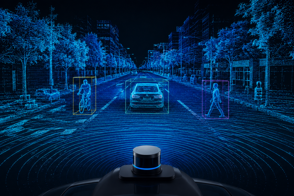
Point cloud dataset quality problems tend to repeat across domains, whether the sensor is mounted on a car roof, a robotic gantry, or a field robot. Most perception failures don’t start at model training. They start earlier, during data capture, sensor calibration, annotation, and dataset assembly, which is exactly why treating quality as a final QA checkpoint is usually too late. Understanding where these issues originate, at the sensor, during calibration, in annotation, or at the dataset level, makes it possible to catch them before they become a downstream model failure.
Sensor-Level Issues That Undermine 3D Point Cloud Dataset Quality
The first source of quality problems is the sensor itself, before any human ever touches the data. This is also where the gap between raw LiDAR datasets and usable training data is widest, since sensor output requires LiDAR data annotation to become model-ready in the first place.
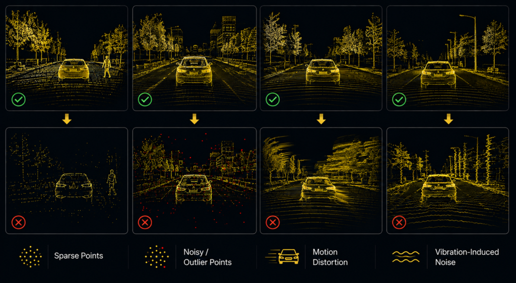
1. Sparsity and uneven point density:
LiDAR returns thin out with distance, so a pedestrian or a small object twenty meters away may be represented by only a handful of points, while the same object at five meters is densely resolved. Structured-light and depth sensors, more common in robotics arms and short-range field applications, show the same near-versus-far density drop-off, just compressed into a shorter range, holding up within roughly five meters and thinning out beyond that instead of the twenty-to-twenty-five meter range typical of LiDAR on AV platforms. Any dataset that doesn’t account for this density gradient will train a model that is confident up close and unreliable at range.
2. Sensor noise and outlier points:
Reflective surfaces, rain, dust, and multipath returns all introduce spurious points that don’t correspond to real geometry. In outdoor AV and agricultural environments this is a constant background problem; in indoor robotics, reflective metal surfaces and glass create similar artifacts.
3. Vibration-induced noise:
Sensors mounted on a moving ego vehicle pick up continuous mechanical vibration from the platform itself, and point clouds captured mid-vibration carry added noise that’s easy to mistake for an environmental artifact rather than a mounting or platform issue.
4. Motion distortion:
Spinning LiDAR units capture a full scene over tens of milliseconds, not instantaneously. A fast-moving vehicle or a robot arm in motion during a scan introduces a shearing distortion into the point cloud that, left uncorrected, embeds a systematic geometric error into every downstream label.
Calibration and Multi-Sensor Fusion Issues
Point cloud data rarely exists in isolation. Most systems fuse LiDAR with camera and sometimes radar, and this is where a second category of quality issues appears.
Extrinsic and intrinsic miscalibration:
If the spatial relationship between a LiDAR unit and a camera isn’t precisely known, projecting one onto the other introduces a consistent offset. In an AV stack, this can misplace a detected object by enough to matter at highway speed. In robotics, the same miscalibration can throw off grasp point estimation on a bin-picking arm.
Temporal synchronization drift:
Sensors that aren’t tightly time-synced can capture the same object at slightly different real-world positions if it’s moving, an issue that compounds in any dynamic scene, from a warehouse robot working alongside people to a field robot tracking a row.
Coordinate frame inconsistency:
Datasets stitched together from multiple capture sessions, vehicles, or robot units sometimes carry inconsistent coordinate frame conventions between sessions. Annotators and downstream training pipelines need one consistent frame of reference, and this is often assumed rather than verified.
Lens variation across sensor units:
Even when each unit’s intrinsic calibration is accurate on its own, different camera lenses across a sensor rig, or across vehicles in a fleet, carry their own distortion profiles. A dataset assembled across multiple rigs or vehicles can end up with subtly inconsistent geometry from one capture session to the next, even though no single sensor is technically miscalibrated.
Annotation-Level Issues in Point Cloud Labeling
Even with clean sensor data and correct calibration, 3D point cloud dataset quality is only as strong as the annotation layer, and point cloud labeling carries challenges that don’t exist in 2D. This is often where 3D data quality is won or lost, since sensor and calibration issues are at least measurable, while annotation inconsistency can hide in plain sight.
Inter-annotator Variance on Boundaries
Unlike a 2D bounding box drawn around a visible object, a 3D cuboid or segmentation boundary often has to be inferred around occluded geometry, the back half of a parked car, the root zone of a plant beneath visible canopy, the far side of a part in a bin. Without a shared standard for how to handle occlusion, different annotators will draw meaningfully different boundaries around the same object.
Inconsistent Boundaries on Irregular Shapes
Point cloud annotation for precision agriculture is a good illustration: crop canopy, overlapping foliage, and uneven terrain don’t have clean geometric edges the way a vehicle or a warehouse box does. Annotators need domain understanding, not just tooling, to label canopy height, stem angle, or root zone proximity consistently.
Class Imbalance and Rare-object Underrepresentation
Common classes like passenger vehicles or standard bins get labeled thousands of times over; rare but safety-critical classes like a cyclist at night, a downed branch on a field, or an unusual part orientation are underrepresented, and a model trained on that imbalance will underperform exactly where it matters most.
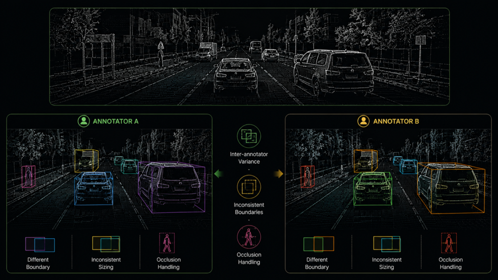
Missing or Inconsistent Occlusion and Truncation Flags
Whether an object is partially occluded or cut off at the edge of a sensor’s range needs to be flagged consistently, or the model has no way to learn the difference between “this object is small” and “this object is far away and partially hidden.
Incomplete Instruction Sets
When a client’s annotation instruction set doesn’t anticipate every scenario an annotator will run into, individual annotators default to their own judgment call. That gap sometimes gets caught in review and corrected, and sometimes doesn’t get caught at all, so the same edge case can end up labeled two different ways across a dataset without anyone flagging it.
Scope Reduction Driven by Cost
Annotation cost pressure sometimes leads a client to narrow the region of interest or reduce the number of object classes covered, rather than annotate the full scene. That’s a reasonable budget trade-off on its own, but it quietly narrows what the resulting dataset can teach a model, since anything outside the reduced scope is never represented at all.
Dataset-Level and Structural Issues
The last category of quality issues shows up after annotation, in how a dataset is assembled and split.
Limited domain diversity:
A point cloud dataset captured in one geography, one season, or one facility layout will encode assumptions that don’t generalize. An agricultural dataset built from a single growing season and region will miss the geometric variation that shows up across crop types and terrain elsewhere. An AV dataset built from clear-weather daytime driving will miss the point cloud characteristics of rain, snow, and low light.Scene leakage between train and test splits:
When frames from the same capture session end up in both training and test sets, evaluation numbers look better than real-world performance will be, since the model has effectively already seen the test scene.No structured QA pass:
A single annotation pass with no independent review tends to let the issues above compound rather than get caught. Point cloud annotation, more than most annotation types, benefits from a verification step precisely because errors are geometric and harder to spot at a glance than a mislabeled image.
Why This Matters for Model Performance
Each of these issues maps to a specific downstream failure mode rather than a vague accuracy hit. Sparsity and density gradients produce models that lose confidence at range. Miscalibration produces consistent localization offsets. Annotation boundary inconsistency produces noisy supervision that widens a model’s uncertainty around real object edges. Domain gaps produce models that perform well in benchmarks and poorly in new environments. Recognizing which failure mode traces back to which stage of the pipeline is what makes a quality problem fixable rather than just visible after the fact.
| Stage | Common Issue | Model Impact |
|---|---|---|
| Sensor | Sparse or noisy returns | Missed detections, unreliable range performance |
| Calibration | Sensor misalignment or sync drift | Consistent localization offset |
| Annotation | Boundary inconsistency, occlusion handling | Noisy supervision, wider uncertainty at object edges |
| Dataset | Domain gap, scene leakage | Inflated validation scores, poor real-world generalization |
Rather than treating QA as a final checkpoint, production teams increasingly validate sensor alignment, annotation consistency, and dataset integrity throughout the data pipeline, not just at the point a dataset is handed off for training.
How iMerit Addresses 3D Point Cloud Dataset Quality
Ango Hub’s 3D point Cloud Tool builds these checks directly into the platform rather than relying on manual review alone.
Temporal Frame Traversal:
Maintains object identity and consistency across sequential frames, helping catch the kind of frame-to-frame annotation drift that motion distortion or inconsistent labeling can introduce across a scene.Cross-modal validation:
Compares LiDAR, camera, and radar sensor data to detect discrepancies and ensure accurate multi-sensor fusion, addressing the calibration and sensor-fusion issues described above before they compound downstream.Field of View and Raycaster:
Field of View highlights which point cloud sections are visible in a selected camera image, helping annotators identify which 3D points correspond to that camera’s perspective. The Raycaster tool projects the cursor’s point cloud position onto the camera images to help annotators identify objects quickly, giving annotators a direct way to resolve the inter-annotator variance that occlusion creates.Custom Ontologies (occlusion-level tagging):
Supports domain-specific taxonomies that include occlusion level as a defined field, directly closing the gap on missing or inconsistent occlusion flags.Logic Nodes:
Let teams define custom conditions that automatically route sequences to different stages, so scenes meeting certain quality thresholds move straight to completion while others requiring additional review are routed accordingly, turning stage-by-stage QA into an enforced mechanism rather than a policy.
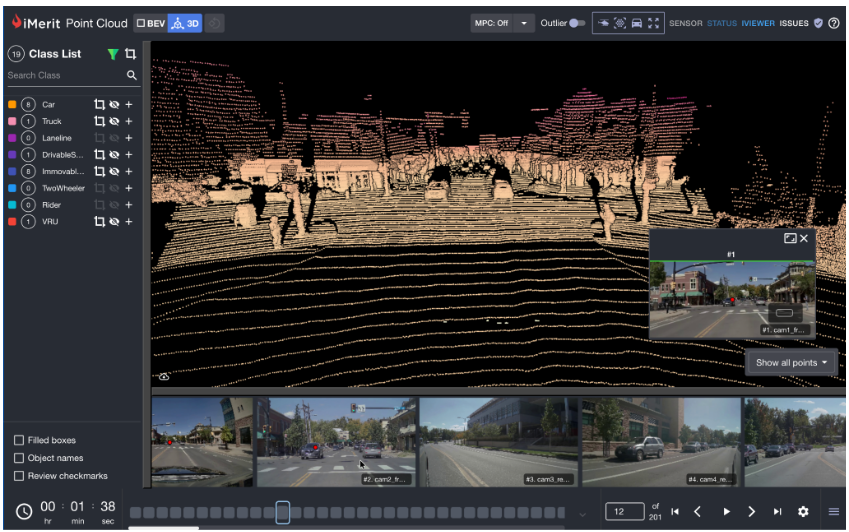
For complex edge cases, heavy occlusion, dense urban scenes, irregular crop geometry, or cluttered manipulation environments, expert review helps maintain annotation consistency where automated checks alone fall short. Domain-trained annotators bring the same judgment a human reviewer would apply to a corn tassel obscured by canopy or a pedestrian partially hidden behind a parked car, which is precisely where inter-annotator variance tends to concentrate.
The impact shows up in production numbers. In one autonomous vehicle program, iMerit’s structured 3D LiDAR annotation workflow helped a Robotaxi client achieve greater than 95% accuracy, a result built on exactly the kind of occlusion-aware, calibration-conscious review process described above rather than raw annotation volume. The same workflow discipline, expert review paired with structured, stage-by-stage QA, applies whether the point cloud is coming from a vehicle’s roof-mounted LiDAR, a robotic arm’s depth sensor, or a field robot’s forward-facing sensor stack.
Conclusion
3D point cloud dataset quality issues rarely come from one bad decision. They accumulate across the sensor, the calibration step, the annotation process, and the dataset structure, and each stage’s errors are harder to catch than the last because they’re geometric rather than visual. Teams building AV, robotics, or precision agriculture systems get the most value from treating quality as something to verify at every stage rather than something to inspect only at the end.
For a closer look at the datasets available for training on 3D point cloud data across these domains, see iMerit’s Master List of 3D Point Cloud Datasets for Industry-Specific Applications
Building reliable perception systems starts with understanding where quality breaks down. The next step is having tooling and review workflows that make those problems visible before models ever reach production.
Explore iMerit’s Ango Hub 3D point cloud annotation tools.