Agricultural sensor fusion requires more than adapting autonomous vehicle systems to farm environments. Field-specific objects, uneven terrain, occlusion, dust, and inconsistent sensor observations demand specialized multimodal datasets. Synchronized annotation, cross-modal correspondence, domain-specific taxonomies, and iterative QA help build reliable training data for agricultural perception models.
A tractor is not a car. That sounds obvious, but sensor fusion systems adapted from autonomous driving can still carry assumptions built for roads. For instance, they assume predictable geometry, flat surfaces, and relatively consistent visibility.
Fields don’t offer any of that. Dust, spray, canopy cover, and uneven ground can affect agricultural sensor fusion in different ways, changing the quality of the inputs a fusion model receives.
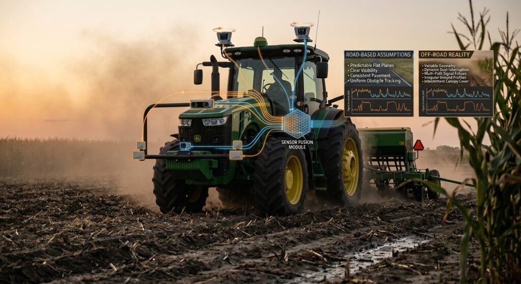
A recent review of agricultural field sensing identifies multi-sensor fusion complexity and the scarcity of specialized agricultural datasets as ongoing challenges in agricultural applications. As perception teams bring AV-trained systems into off-road equipment, those differences create problems not only for the model, but also for the data used to train it.
This article examines where road-based sensor fusion assumptions break down and what agricultural models need at the data and annotation level.
Why AV Sensor Fusion Break Downs on Farm Equipment
Road-based perception systems operate within a relatively structured visual and geometric environment. Farm equipment operates across less consistent scenes and tasks, changing how sensor observations need to be interpreted by the fusion system.
Structured vs. unstructured environments:
Road geometry gives perception models recurring reference points such as lanes, road edges, and intersections. In fields, there may be no fixed boundaries at all. Crop rows can curve, disappear, or change with the growing season, while terrain and field layouts vary between locations. This leaves the model with fewer stable geometric cues to rely on.
Object taxonomy mismatch:
Road-oriented models are built around categories such as cars, pedestrians, and cyclists. Agricultural sensor fusion may need to distinguish crops from weeds, livestock, implements, irrigation equipment, field boundaries, and other obstacles. These are not simply new object classes, and they can require different ways of defining and relating what the model sees.
Motion and operating profiles differ:
Agricultural machinery moves slowly but makes frequent stops, tight turns, backing movements, and changes in direction. Headland turns at row ends are a clear example, often involving multi-point switchback or omega maneuvers not represented in typical road-driving datasets. These operating patterns can change the machine’s trajectory and sensor viewpoint in ways that road-trained perception systems may not be designed to handle.
Dust and crop spray disrupt sensor reliability:
Dust and spray can degrade camera inputs and produce noisy or incomplete LiDAR returns. Radar may remain useful in some conditions, creating uneven information quality across modalities rather than a consistent view from every sensor.
Canopy and vegetation create persistent and partial occlusion:
Vegetation can hide an object from one sensor while leaving part of it visible to another. The fusion system therefore has to interpret incomplete observations across modalities.
Uneven terrain changes perception geometry:
Slopes, furrows, ruts, and changing ground surfaces affect the machine’s pose and the geometry captured by its sensors. Small shifts in position and orientation as the machine moves over uneven terrain can change the sensor viewpoint between frames, even when the surrounding objects remain stationary.
These conditions don’t just degrade individual sensors. They change what information is available to the model and how that information needs to be represented in training data.
Appropriate annotation logic can help agricultural multi-sensor models learn from these inconsistent inputs. However, road-based annotation pipelines have their own limitations in agricultural settings.
The Annotation Challenges in Agricultural Sensor Fusion
Fixing the perception gap on paper is one thing. Fixing it at the multi-sensor data annotation layer, where models actually learn what to look for, is a different problem entirely. The challenge is not simply collecting more sensor data, but that the training set has to represent agricultural objects, relationships, and sensor observations in ways that match the tasks the model will perform.
Rigid Object Representations
Conventional AV datasets often rely on 2D or 3D bounding boxes for discrete objects. Agricultural perception can involve structures that are irregular, spatially distributed, or only partly observable, making a single box an incomplete representation.
Plant structures, crop regions, and other agricultural features may need segmentation or 3D point-level labels to capture their boundaries and location more accurately.
A 2024 study introducing the Crops3D dataset reflects this need in practice. The dataset uses instance- and organ-level segmentation to label real-world 3D point clouds across eight crop types. The authors note that plant structures become increasingly complex and self-occluded as crops mature, making segmentation useful for capturing their structure in the dataset.
Ontology Gaps
Agricultural perception systems need to distinguish agricultural vehicles, implements, crops, field objects, and other task-specific categories that are not represented in conventional road-oriented taxonomies.
Common object-detection benchmarks, such as COCO, include objects found in agricultural environments. But their taxonomies were not designed for agricultural perception and omit many field-specific categories.
A 2026 study on agricultural obstacle detection also notes that widely used benchmarks do not adequately reflect the categories and data distributions found in unstructured agricultural environments
Multi-Modal Data Complexity
Multi-modal datasets bring together sensor data with different formats, sampling rates, and spatial references. For annotation, these differences matter because observations from each sensor still need to be linked to the same object or scene element. For instance, an object may be clearly visible in a camera frame. However, it may appear only partially in LiDAR or not be detected by another sensor at all.
IMU data adds another layer of complexity. Unlike cameras, LiDAR, or radar, it does not directly capture observations of scene objects. It provides motion measurements of the platform, so its data needs to be time-aligned and fused with the other modalities rather than spatially matched to a specific object.
A 2024 review of agricultural field sensing identifies sensor diversity and fusion complexity as continuing challenges in multi-sensor agricultural systems.
Agricultural Dataset Scarcity
Even an appropriate annotation scheme is difficult to scale when suitable agricultural datasets are limited. Public datasets that combine sensor data with high-quality ground truth remain relatively scarce. This makes it harder to train and evaluate perception models across diverse agricultural conditions and tasks.
The 2023 RGB-D survey found that high-quality public agricultural datasets were rare and that collecting suitable sensor data and ground truth was challenging and labor-intensive.
What Agricultural Multi-Sensor Models Need
Agricultural multi-sensor models need training data that reflects how perception works in the field. They must recognize objects across different sensor views, work with partial observations, and distinguish field-specific objects and conditions. That means the annotation strategy has to account for more than just object location.
1. Synchronized, Condition-Aware Multi-Sensor Data Annotation
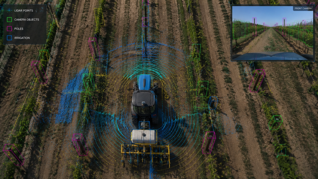
An agricultural sensor fusion model needs to know what each sensor observed at the same point in time. Simply matching timestamps is not always enough. The training data should also preserve whether a sensor had a clear view, a degraded observation, or no usable observation.
For instance, if vegetation blocks a camera while LiDAR still captures part of an object, the object can remain annotated while the camera observation is marked as occluded. LiDAR can retain the visible geometry, so the model can learn that the difference between the two modalities results from visibility conditions rather than treating it as conflicting ground truth.
Sensor visibility, availability, or quality attributes can be attached to frames or relevant objects to preserve this information. This gives the model a clearer distinction between an object that is absent and one that a particular modality failed to observe.
iMerit’s multi-sensor annotation capability via Ango Hub, including synchronized labeling across LiDAR, camera, and radar streams, supports the agriculture-specific fusion annotation that AV-trained teams consistently underestimate.
2. Cross-Modal Correspondence
The same physical object should remain identifiable across the model’s sensor representations. A person, vehicle, or field obstacle may have a 2D region in a camera image, a 3D point cluster in LiDAR, and a separate radar return. These representations need shared object identities or corresponding labels so the model can learn their relationship.
This correspondence can be created by using the known spatial relationship between sensors. For example, a 3D LiDAR point cloud can be projected onto a camera image using the sensors’ calibration parameters. Points that fall within an object’s 2D mask can then be associated with that object, linking its image and 3D representations.
A 2026 study on vine-trunk localization applies this approach by identifying vine trunks across different sensor modalities and matching them based on their position. This allows the same objects to be represented across modalities as a single label rather than annotated separately for each sensor.
3. Domain-Specific Taxonomies
The model can only learn distinctions that exist in its training labels. Agricultural taxonomies need to reflect the actual perception task. For instance, crops may need to be distinguished from weeds, agricultural implements from other vehicles, and terrain features from obstacles.
The same principle applies to attributes. If the model needs to reason about properties such as growth stage, visibility, or object condition, those properties need to be represented in the training data.
The practical approach is to start from what the model needs to decide, whether that’s identifying a crop’s growth stage or distinguishing an implement from another vehicle, and build the taxonomy around those distinctions first. Once those classes and attributes are defined, they should be applied consistently across the sensor modalities the model uses. This way, the same object or attribute has a consistent meaning across camera, LiDAR, and other sensor data.
4. Occlusion and Edge-Case Annotation
Models need examples of the partial and uncertain observations they will encounter in the field. Training data should include different levels of visibility, partially observed targets, and cases where information is missing from one modality but available in another.
Occlusion and visibility attributes, partial-object annotations, and sensor-availability labels can record what each sensor can actually observe in a frame. A study of multimodal agricultural perception shows canopy occlusion can limit observations from individual sensors, particularly when vegetation blocks parts of the scene. This highlights the need to represent partial and sensor-specific observations explicitly in the training data.
5. Iterative Annotation and QA
The training data needs reliable ground truth across rare, seasonal, and difficult field conditions to prevent systematic annotation errors from reaching the model. Rare crop stages, unusual obstacles, difficult viewpoints, and repeated disagreements between modalities may only become apparent during dataset review or model testing.
Model failures can then help identify gaps in the dataset or annotation schema. QA and re-annotation can resolve ambiguous labels, missed objects, inconsistent attributes, and recurring cross-modal disagreements.
Teams can use these findings to expand the dataset and refine the annotation logic, reducing the risk of repeated errors becoming patterns in the training data.
Conclusion
Agricultural sensor fusion needs more than an AV sensor stack adapted to a different environment. Field conditions introduce different objects, partial observations, sensor gaps, and annotation requirements that directly affect what perception models learn. Better model architectures alone cannot solve these gaps if the training data does not represent them accurately.
Key takeaways
- Agricultural perception requires annotation schemes designed around field-specific objects, conditions, and tasks.
- Multi-sensor datasets require consistent relationships among LiDAR, camera, radar, and IMU data.
- Occlusion, partial observations, and sensor-specific gaps should remain represented in the training data.
- Iterative QA helps teams identify annotation errors and refine datasets as model failures reveal new gaps.
- Domain-specific annotation infrastructure provides perception teams with a stronger foundation for training and evaluating agricultural sensor fusion models.
For perception teams moving from automotive to agriculture, the annotation layer becomes a critical part of adapting the perception stack. iMerit helps teams build and refine multimodal agricultural datasets through its multi-sensor annotation capabilities in Ango Hub. It supports annotation across LiDAR, camera, and radar data while maintaining the structure needed for complex fusion workflows.
Building sensor fusion for precision agriculture? Schedule a call with iMerit to discuss your multimodal annotation requirements.