Path planning trajectory labeling only works when a model has actually seen the maneuver it is being asked to perform. Open-field autonomy handles wide, sweeping turns without much trouble, but that breaks down the moment a vehicle enters an orchard.
Picture a tractor reaching the end of a row, boxed in by trees on three sides with barely enough room to turn. A model trained on open-field headland turns has no template for the multi-point maneuver this space demands. The problem deepens as GPS coverage weakens under canopy, right where precise positioning matters most.
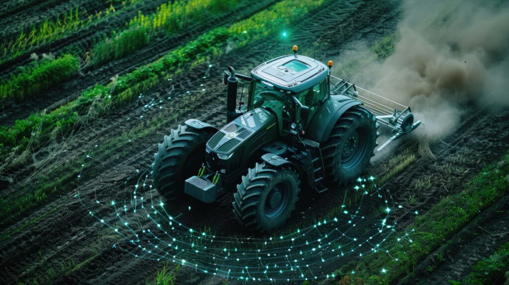
Research from the University of California, Riverside found that a single LiDAR sensor, tuned with adaptive odometry, held centimeter-level localization even under that canopy. Sensing, then, has a workable answer; the missing piece is teaching the model the maneuver itself.
This article looks at why headland turns break standard navigation models, and how targeted path planning annotation builds the maneuvers orchards actually require.
Why Headland Turn Navigation Breaks Standard Training Data
Headland turns are where orchard navigation exposes the limitations of autonomous driving systems. Driving between rows is relatively predictable because the tractor follows an established path with consistent lateral guidance. Turning at the headland is different. The planner must exit the current row, select a feasible turning path, avoid nearby obstacles, and align precisely with the next row, all within a confined space.
If the turn is misjudged, every subsequent decision from obstacle avoidance to row alignment and implement positioning becomes more difficult. What makes headland turns so difficult is not a single limitation but a combination of challenges that standard agricultural training data rarely captures. Let’s see what those challenges are!
Sweeping Arcs vs. Switchback and Omega Turns
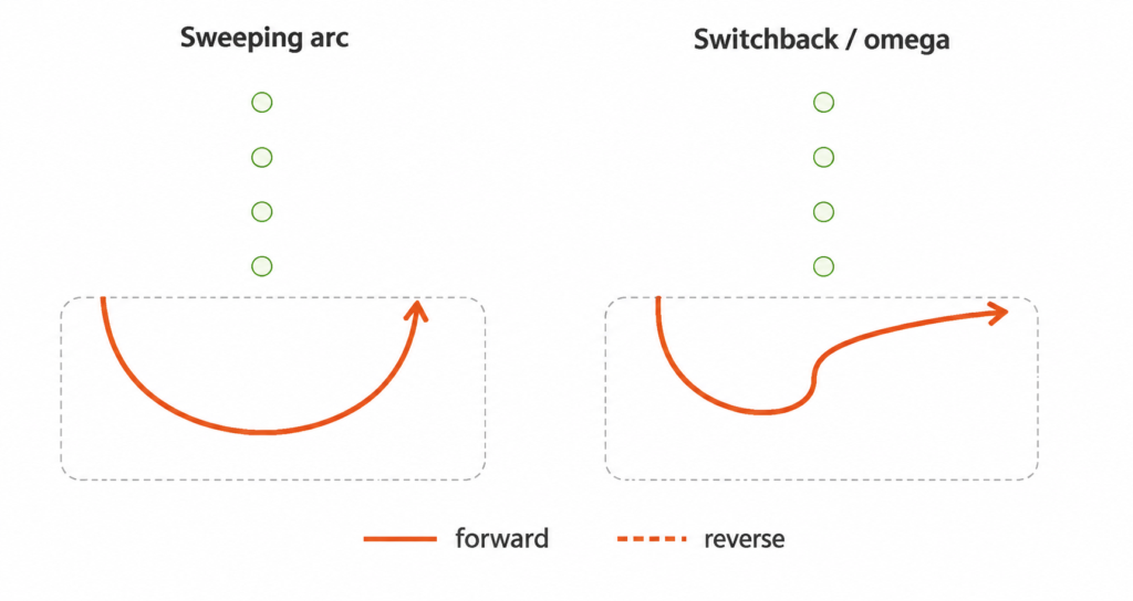
Most navigation datasets emphasize smooth, single-arc U-turns because they are common in open fields. Orchard headlands rarely provide that luxury. Narrow turning areas can require tractors to perform switchback or omega turns, which involve more complex trajectory planning within constrained spaces.
Headland Width Isn’t Constant
A navigation model cannot assume every headland offers the same turning clearance. Row spacing, tree age, planting layout, and infrastructure all influence how much room is available, sometimes changing between neighboring blocks.
Rather than relying on fixed geometric assumptions, autonomous systems must learn to estimate available turning space. Accurate annotation exposes models to these variations, helping them generate paths that match real orchard conditions.
Where the Row Ends and the Headland Begins
Unlike paved roads, orchards rarely provide clear visual cues to mark where a row ends and the headland begins. The transition may appear only as a gap between trees, irregular vegetation, or subtle terrain changes. These unclear boundaries make localization and maneuver planning more difficult.
Research on orchard navigation shows headland turning as one of the most challenging phases of autonomous operation. This is because planners have to simultaneously reason about turning constraints, irregular boundaries, obstacle avoidance, and localization uncertainty.
Obstacles That Open Fields Don’t Have
Unlike open farmland, orchard headlands contain dense infrastructure that directly affects turning decisions. Irrigation risers, trellis posts, support wires, harvested fruit bins, pump houses, drainage channels, and utility sheds reduce maneuvering space and create irregular driving corridors. Many of these objects appear infrequently in conventional agricultural datasets. This limits a model’s ability to classify them or predict safe avoidance paths.
Detailed annotation teaches perception systems to recognize orchard specific obstacles and enables planners to generate collision-free trajectories around them.
Canopy Overhang Changes the Clearance Math
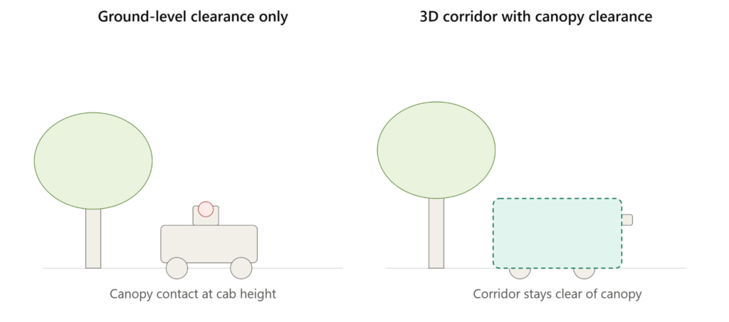
Safe turning is not only about avoiding obstacles at ground level. Tree branches often extend into the tractor’s turning envelope. This reduces usable clearance from above even when the ground appears unobstructed.
A planner relying only on flat and two-dimensional clearance calculations can select a path that avoids trunks yet still clips the canopy. Representing overhanging vegetation during annotation can help models to learn the true navigable space instead of assuming every overhead area is safe.
The difficulty is not that orchard headlands are more complex than open fields, but that many of these conditions are poorly represented or entirely absent from conventional training datasets.
Why Better Algorithms Alone Won't Solve Orchard Navigation
Advances in reinforcement learning and sensor fusion have improved autonomous navigation. However, reliable orchard navigation still depends on training data. Even the most advanced planner cannot learn a maneuver or obstacle interaction that is missing from its training data. If a model has never seen a tight headland turn or an irrigation riser shaping the available path, it has no reference for handling that situation in the field.
Three data challenges limit navigation performance in orchards:
- Changing sensor conditions: Orchard environments introduce dense canopies, shifting shadows, uneven lighting, and partial occlusion that reduce the quality of camera and LiDAR data. Overhead foliage can also weaken Global Navigation Satellite System GNSS signals and reduce localization accuracy.
- Limited environmental diversity: The same orchard can look very different across crop types, seasons, pruning stages, weather conditions, and times of day. Without representative annotated examples, models often fail to generalize beyond the conditions they were trained on.
- Incomplete orchard-specific annotations: Generic agricultural datasets often lack detailed labels for tree trunks, overhanging canopies, irrigation risers, trellis posts, fruit bins, and other orchard infrastructure. Without these annotations, perception models struggle to classify important objects and provide planners with the context needed to generate safe trajectories.
High-quality data annotation can help to address these challenges by exposing models to the real maneuvers, orchard-specific obstacles, and changing environmental conditions they will encounter in commercial orchards.
What Orchard-Specific Trajectory Labeling Requires?
Good orchard navigation isn’t built on generic training data. It’s built on edge case labeling that reflects how orchards actually look and how a machine actually moves through them, row by row, turn by turn. That means going well beyond marking obstacles and calling it done.
At iMerit, orchard navigation trajectory labeling has to capture full maneuvers rather than isolated moments, account for real three-dimensional space, hold up across different orchard layouts, and keep pace with how conditions shift across a growing season. Here’s what that actually looks like.
Sequence Annotation of Full Turn Maneuvers
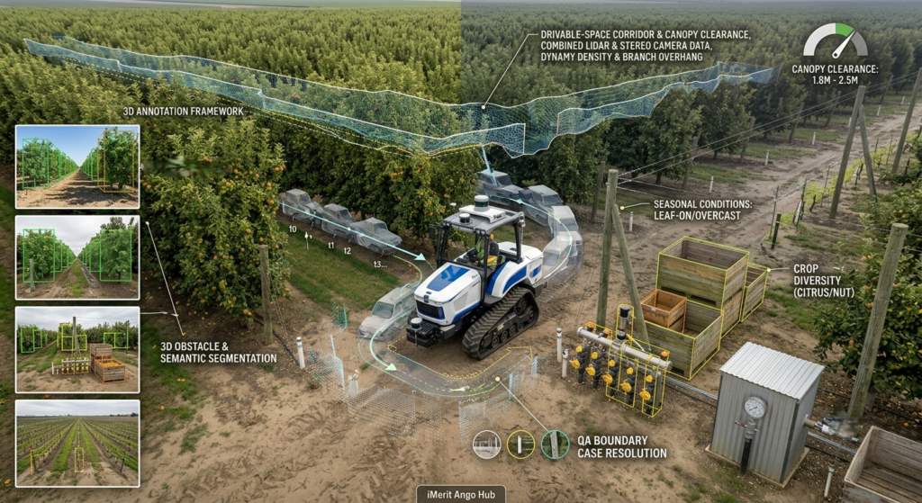
Headland turns should be annotated as continuous motion sequences rather than individual images. Similar to video annotation for machine learning, each frame must preserve the temporal relationship between steering angle, vehicle position, and surrounding obstacles. A single frame may show where the vehicle is, but it cannot explain how it entered that position or where it should move next.
Sequence annotation helps navigation models to learn the decision-making process behind multi-point turns instead of reacting frame by frame.
3D Bounding Boxes and Segmentation for Static Obstacles
Orchards contain permanent structures like irrigation risers or fences that directly affect path planning. Teams annotate these objects using accurate 3D bounding boxes and semantic segmentation across camera and LiDAR data. This helps the model understand each object’s location, size, and relationship to the surrounding environment.
Detailed object classes help the planner estimate available clearance more accurately. They will be able to distinguish between different types of infrastructure and plan safer paths around fixed obstacles instead of treating every object the same.
Drivable-Space Annotation That Accounts for Canopy
In orchards, drivable space extends beyond the ground surface. If data annotation only defines drivable ground, the planner never learns that overhead clearance matters too.
Representing navigable space as a three dimensional corridor can help to capture both horizontal and overhead clearance. This provides planning models with a more realistic representation of the vehicle’s operating envelope and reduces collisions caused by obstacles that lie above the sensor’s ground projection.
Coverage Across Crop Types
No two orchard systems share the same geometry. Apple orchards, citrus groves, almond plantations, vineyards, and other specialty crops differ in row spacing, canopy density, and headland configuration. Training data should therefore include annotations from diverse crop types rather than relying on a single orchard layout.
This same principle already applies to crop specific datasets used for precision spraying, where diversity across crop types improves how well a model generalizes. The same logic holds for navigation: exposing models to a wider range of orchard layouts helps autonomous tractors adapt to new designs without extensive retraining.
Coverage Across Environmental Conditions
Orchard appearance changes throughout the year. Trees transition between leaf-on and leaf-off conditions, lighting shifts from bright sunlight to deep shade, and wet ground alters both appearance and vehicle dynamics.
Research shows that stable orchard perception depends on training across different tree morphologies and changing environmental conditions so perception models learn to recognize the same scene under different conditions. Moreover, including representative annotations across seasonal, weather, and lighting variations can help to improve robustness under real operating conditions.
QA for Ambiguous Boundary Cases
Many annotation errors occur where the production row transitions into the headland. Because these boundaries are rarely explicit, annotation teams need documented labeling rules and structured quality assurance workflows to ensure consistency.
iMerit Ango Hub supports multi-stage review processes that help enforce these standards across large datasets. Consistent labels teach models a stable definition of drivable space, while inconsistent annotations introduce conflicting examples that reduce navigation accuracy during headland turns.
How iMerit Helps Label Orchard-Ready Edge Cases?
Autonomous orchard navigation depends on training data that reflects the conditions vehicles encounter in the field, especially the rare edge cases that cause navigation systems to fail.
iMerit supports agricultural AI teams with high-quality annotation services for precision agriculture and robotic vision. These services cover image, video, 2D LiDAR, 3D point cloud, and multi-sensor data, including land, crops, weeds, pests, orchard infrastructure, and navigation scenes. This helps build the data foundation for autonomous tractors and other precision farming applications.
Beyond edge case labeling and annotation at scale, iMerit helps engineering teams build high-quality datasets for autonomous navigation. Ango Hub combines AI-assisted annotation, production analytics, and structured quality assurance workflows to improve annotation quality and efficiently manage large-scale data operations.
For organizations already using iMerit for precision spraying, crop and weed annotation, or other agricultural AI projects, the same orchard expertise can extend to path planning and maneuver annotation. This will create a consistent data strategy across perception and navigation pipelines and help autonomous tractor developers build more reliable models for real-world orchard operations.
From Trajectory Labeling to Model Behavior: What Changes for Autonomous Tractors
High-quality trajectory labeling changes how autonomous tractors plan and execute headland turns. Instead of reacting to obstacles or tight spaces after entering the maneuver, models trained on maneuver-labeled datasets can anticipate the required trajectory much earlier.
This leads to several improvements in navigation performance:
- Earlier turn prediction: Models identify the required maneuver, such as a switchback, omega turn, or continuous arc, before reaching the headland. This allows them to plan the turn earlier.
- More reliable trajectory planning: Rich obstacle labels and drivable-space annotations help planners generate safer paths. They also maintain proper clearance around orchard infrastructure.
- Fewer manual interventions: Better planning reduces manual overrides, branch or trellis contact, and poor alignment. This improves row entry after each turn.
- Improved adaptability: Models perform more reliably across different row widths, tree spacing, canopy structures, and orchard layouts. They also require less retraining and planner tuning.
- Lower deployment costs: Early annotation of orchard-specific edge cases helps teams identify and fix navigation issues before field testing. This reduces development time and costs.
By learning from representative orchard scenarios, autonomous tractors can handle real-world headland maneuvers more reliably.
Best Practices for Training Navigation Models for Specialty Crops
Building a robust navigation model is an iterative process. Beyond high-quality annotation, teams also need a disciplined data collection and evaluation strategy that exposes models to the full range of orchard conditions they will encounter in production.
The following best practices provide a practical framework for doing that.
- Collect geographically diverse datasets. Include different orchard layouts, crop types, row spacing, and headland designs to improve generalization.
- Balance routine and edge case Ensure tight turns, occluded obstacles, irregular row exits, and constrained maneuvers are well represented.
- Combine perception and path planning trajectory labeling. Label both what the tractor sees and how it should navigate through those conditions.
- Include multiple tractor configurations. Capture different vehicle sizes, turning radii, and attached implements to reflect real operating conditions.
- Capture seasonal and lighting variations. Train across leaf-on and leaf-off conditions, wet and dry terrain, and changing illumination under canopy.
- Continuously expand edge case libraries. Use production data to identify new failure scenarios and feed them back into the training pipeline.
- Measure the right metrics. Track headland-specific KPIs such as turn completion, row re-entry accuracy, clearance violations, and manual interventions and not just overall navigation accuracy.
Autonomous tractors can navigate real-world headland maneuvers more reliably by training on representative orchard-specific scenarios.
Conclusion
The hard part of orchard autonomy was never the open field. It’s everything that happens at the end of the row.
Headland turns compress every challenge open-field navigation never had to face: tight, irregular space, obstacles that don’t exist on a flat plain, canopy overhead, and boundaries with no painted line. A stack trained mostly on open-field data doesn’t fail loudly here. It just doesn’t know what to do.
Solving this isn’t about writing a smarter turning algorithm. It’s about giving the model examples of the maneuver it actually needs to make.
Key Takeaways
- Headland turns need sequence-level annotation, not single frames, so models learn the full maneuver.
- Orchard-specific obstacles and overhead canopy require 3D, not just ground-level, labeling.
- Coverage across crop types and conditions keeps models from overfitting to one orchard.
- Consistent boundary rules prevent contradictory training examples.
iMerit builds orchard-specific path planning and annotation pipelines for teams expanding into specialty crops. Talk to an Expert to close the orchard data gap in your navigation stack.